Plugin categories

Create a Website with AI
GPX Viewer: Pricing, Instructions, Reviews and More

GPX Viewer: Pricing, Instructions, Reviews and More

Explore the features and benefits of the GPX Viewer plugin, perfect for enhancing your mapping experience with detailed insights and tools.

3.8

Rating summary

5

Reviews

700

Active installations

GPX Viewer: Pricing, Instructions, Reviews and More

Overview

Compatibility

Installation instructions

Customer support & learning resources

Changelog

Main benefits

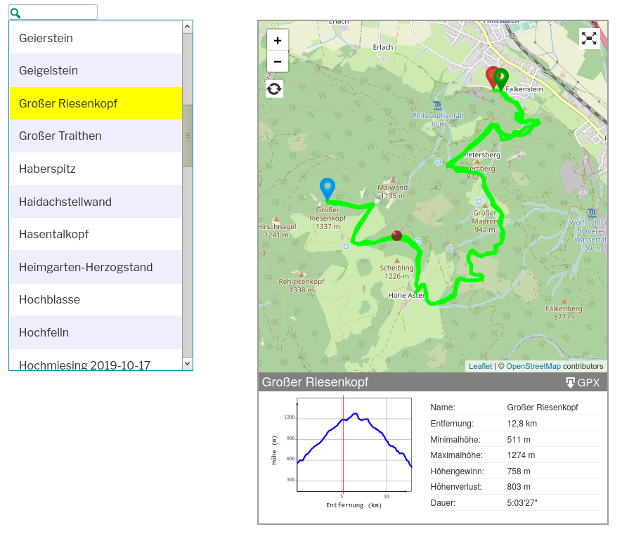
Segmented polylines display

Interactive elevation profile

Full screen mode

Category-based repositories
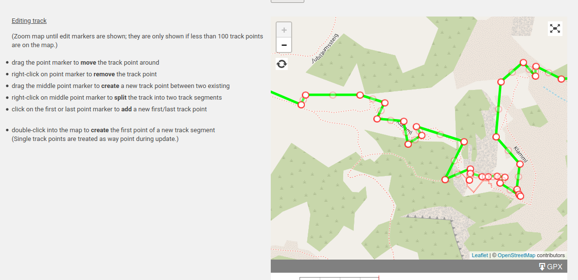
Trackpoint editing

About this plugin

Categories: Media Management
Version: 2.2.8
Last updated: 30-08-2024
WordPress version: 4.9
Tested up to: 6.6.2
PHP version required: false
Languages: Deutsch, Ελληνικά [+1]

Overview

This WordPress plugin is designed to enhance the display and management of GPX tracks by allowing segmented polylines visualization, waypoints, and elevation profiles. It utilizes Open Street Map (OSM) as a background, offering the option to switch between plane and topographic views and supports full-screen mode for an immersive experience. GPX tracks can be uploaded to the server, stored in categorized repositories, and smoothed or corrected for elevation data using the Open-Elevation Service. Users can interactively edit trackpoints on the map, including adding, moving, and deleting points or creating and splitting polylines. The plugin features an admin page for GPX file uploading, a PHP function and shortcode for displaying tracks and lists in posts or pages, and an elevation profile that interacts with cursor movements, showing details like name, distance, elevation changes, and estimated trail duration.

Interactive GPX Track Display

  • Displays GPX tracks as segmented polylines.
  • Shows waypoints and elevation profiles.
  • Interactive path marking by moving the cursor over the elevation profile.

Customizable Map Views

  • Uses Open Street Map (OSM) as background.
  • Switch between plane and topographic views.
  • Full screen mode and map scaling options.

Advanced Track Management

  • GPX tracks are stored in categorized repositories.
  • Tracks can be smoothed and elevation data replaced during upload.
  • Separate lists for each category with customizable path width and color.

Interactive Track Editing

  • Edit trackpoints directly on the map.
  • Add, move, and delete track points.
  • Create and split polylines interactively.

Features list

Feature

Premium version

10 websites

Allows usage on up to 10 websites.

1 year Product Updates

Includes updates for the product for one year.

1 year Product Support

Provides customer support for one year.

30-Day Money-Back Guarantee

Offers a full refund within 30 days of purchase.

Pricing

ESSENTIAL (Pro) Map Route Manager

$59 / one-time

Plan includes

1 website
1 year Product Updates
1 year Product Support
30-Day Money-Back Guarantee
Buy Now

ULTIMATE Map Routes + Map Location + 5 Add-ons

$149 / one-time

Plan includes

10 websites
1 year Product Updates
1 year Product Support
30-Day Money-Back Guarantee
Buy Now

In some cases companies have different prices based on various components like a location. As a result the prices displayed here can differ from the ones you see on their websites.

See all pricing options

Rating and reviews

3.8

Rating summary

5

Reviews

700

Active installations

5
4
3
2
1

User sentiment analysis

Users appreciate the plugin's core functionality and how well it performs its primary task. It's especially valued for creating running statistics, suggesting potential enhancements like different time-based states and compatibility with various map types for activities like trekking. However, there are concerns regarding security, as one user reported a notification from Wordfence about a modified file, although it’s uncertain if this poses a real risk. Some issues have been noted with Safari, requiring CSS adjustments, and users have also mentioned the lack of responses to posted issues. They hope for more map options and a feature to display the author of GPX files.
landomaaat94

landomaaat94

07 May, 2024

Great plugin, does exactly what it’s supposed to. From me, it’s 4 stars. If there are no security issues, it’s a solid 5-star rating. @ Alex How about the code quality here? I’ve installed Wordfence on my project and after 3 hours, a security notice popped up indicating that the file had changed. No malicious code can be injected here, right? I look forward to your feedback 😀 Filename: /…/…/…/wp-content/plugins/gpx-viewer/js/gpxCleaner.js Message Wordfence: This file belongs to plugin “GPX Viewer” version “2.2.5” and has been modified from the file that is distributed by WordPress.org for this version. Please use the link to see how the file has changed. If you have modified this file yourself, you can safely ignore this warning. If you see a lot of changed files in a plugin that have been made by the author, then try uninstalling and reinstalling the plugin to force an upgrade. Doing this is a workaround for plugin authors who don’t manage their code correctly. This topic was modified 3 months ago by landomaaat94.
porkburn

porkburn

02 Sep, 2022

This plugin has great potential to become a full running statistics for WP Idea: – Week, month and year state – Maybe something like citystrides.com (were you run all the streets in a city) – Sotering at various clubs and or areas
Sandy Janas

Sandy Janas

20 Aug, 2022

This plugin is just what I’ve been looking for and does the job well. Just a few points, firstly the full-screen mode doesn’t seem to work with Safari browser (you get a black screen), although it seems fine with every other browser I’ve tried, secondly, I’ve had to add a css statement .content { width:100%; } to get the table to float alongside the graph on Safari. These are probably Safari quirks rather than problems with the plugin. One other thing: I’d like a way to display the Author of the GPX file, to give them credit for it. Apart from those issues, I really like this plugin very much. This topic was modified 1 year, 11 months ago by Sandy Janas. This topic was modified 1 year, 11 months ago by Sandy Janas.
drohdekage

drohdekage

22 Feb, 2022

…you should not complain about Opensource-tools, but this one is simply not working – and posted issues are completely ignored.
pduval34

pduval34

22 Jan, 2021

Perhaps interesting plugins. Unfortunetely, just one map type. I would like to use it with open Topo Map for trekking. Possible to Improve it ? Thanks a lot.

FAQ

What is the main functionality of the plugin?

Can the map view be changed?

How does the elevation profile interact with the map?

How are GPX tracks managed?

What options are available during the upload of a GPX track?

Why is the Open-Elevation Service data used?

Can GPX trackpoints be edited?

What features are available for displaying a GPX track?